Drive from Jasper via Lake Louise to Banff - Two of the most famous national parks
- On Canada's most beautiful road - Mountains over mountains - Turquoise lakes
- Waterfalls and canyons - Ice fields and glaciers
Travel data
| Date of the journey | October 2001 |
| Duration | 3 days |
| Report online since | 25.11.2019 |
| Updated | 25.11.2019 |
Day 1: Mount Edith Cavell, Athabasca Falls, Columbia Icefield, Saskatchewan Crossing
We spent three days in Jasper, the "capital" of Jasper National Park, and now we're heading south to Banff.
The route is supposedly the most beautiful road in Canada, and so we want to take much more time
than the coaches that they usually complete it in one day, so that the passengers at most stops can not do much more than to go to the toilet.
Get up at 7 o'clock, outside it is dark and foggy. Showering and packing, a quick breakfast,
around 9 o'clock we leave Jasper. At the railroad crossing we learn how long the freight trains really are.
This one just does not seem to end.
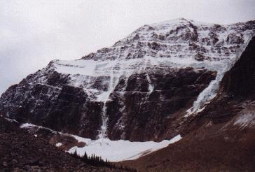
Mount Edith Cavell
| | |
Our first destination is Mount Edith Cavell, the highest mountain in the area. Already from Jasper
we could see its snow covered pyramidal hood, now we will get up close. From the road 93A a 12 km long
serpentine road branches off. It climbs higher and higher, we drive directly into the fog and see nothing at first. At some point,
however, the fog is over and we are able to see the whole panorama of the surrounding mountains.
At 9.45 am we are at the parking lot.
Only two cars have arrived before us, it is very cold. At the parking lot begins the "Path of the Glacier Trail".
A 1.5 km long circular path that leads to a small lake at the foot of the mountain. From here, the mountain rises
1600 m almost vertically in the height, and here the Angel Glacier flows into the lake. Icebergs dissolved from the glacier
float on the surface, which is covered by a very thin layer of ice so early in the morning. An impressive sight,
you almost feel like being transferred to Greenland or the Antarctic.
We can hardly tear ourselves away from this, we stay here for a long time, shooting countless photos.
But at 11.30 am we drive back. Meanwhile, more cars and people arrived. No wonder,
hardly any other place in the Rocky Mountains can easily offer such an alpine landscape.
We drive back down the narrow Edith Cavell Road and then south. Highway 93 is now the actual Icefields Parkway.
The weather is getting better. The Icefields Parkway runs through a fantastic mountain landscape,
its name comes from the many glaciers and ice fields, which can be seen during the journey and to which one
can also approach very close.
|

The Icefields Parkway, Canada's most beautiful road
|
Next stop is the Athabasca Falls, where the wide Athabasca River pours into a narrow ravine.
Beautiful pictures with deep blue water and mountains in the background. The sky is blue now. A popular stop
is the one with a huge parking lot. All coaches are already there.
The next interesting points would have been "Goat Mineral Lick". The mineral-rich earth attracts goats
that lick this earth. Unfortunately the parking lot is closed due to work in progress and we have to continue.
Then come the Sunwapta Falls. Here, the water flows through a deeply cut narrow gorge. The whole thing
is not as impressive as the Athabasca Falls.
The day is now marked by countless views and photo stops. Of course you should only stop at the official parking lots,
but after all we have low season... Slowly we approach the glaciers that gave the road its name. Snow-capped mountains
have been around for a long time, now the Columbia Icefield comes into view.
The largest ice field of the Rockies consists of eight glaciers. The Athabasca Glacier is easily accessible
from the road. Not without reason the Visitor Center has settled here.
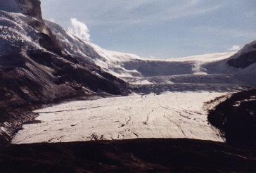
Broad and powerful, the Athabasca glacier seems to roll towards you
| | |
Of course we want to go to the glacier first. From the parking lot it is only a few hundred meters,
then we are at the end of the glacier tongue. The glacier is much wider than Mount Edith Cavell.
Many people are running around, though urgently warned. In 1994, a German fell into a crevasse, the recovery took two hours,
and until then he was frozen to death. Truly tragic, but that does not seem to stop anyone from taking a walk on the glacier.
With Brewster buses you can drive on the glacier, which is probably the safer option. They are custom made
and they only ride in the upper part, where there are not that many crevasses. However, the last departure
is already over, so we have to give up this pleasure.
The Visitor Center on the other side of the street is the finest. A spacious building with information desks,
souvenir shops and luxurious toilets. In addition a big model of the Columbia Icefields.
At 4.30 pm we continue. Soon we reach the border to Banff National Park. A difference to the Jasper National Park
is not visible. The weather is still fantastic. And there are still countless viewpoints that we use for photo stops.
So we get to Saskatchewan Crossing until about 6pm. This is not a city, but actually a large parking lot
at a crossroads, where a restaurant, a pub, a souvenir shop, a gas station and a motel have settled. Here we take a room
that is much cheaper than we had feared.
Day 2: Peyto Lake, Lake Louise, Plain of the Six Glaciers
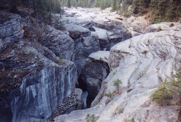
Hardly to make out is the river at the bottom of the Mistaya Canyon.
| | |
At 7.30 am we get up, the night was icy cold, the car windows are frozen. In the meadow next door a herd of wapiti-deer grazes.
Unfortunately, when I come back with my camera, they are already gone. Only their legacies are yet to be discovered.
We have breakfast cereal with cold milk from our stock and leave at 9 clock. First stop at Mistaya Canyon.
No visitor except us. Either the canyon is too unknown, or it is too early. The Mistaya River has carved itself
deep into the rock here, the rock walls go down vertically, at the bottom you can see the small creek that is responsible for this.
The weather is fantastic again, as are the landscapes and viewpoints. A few photo stops later, we come to the next highlight,
Peyto Lake. A huge parking lot and a big hustle and bustle. 500 m you have to go to the observation deck. When we arrive,
we almost get hit. If there were a few tables with t-shirts and socks, you'd think it was the opening of the winter sales.
Apparently at least three coaches had arrived at the same time. It costs a bit of effort to catch a glimpse
of the lake, and then you are rattled back unfriendly because you appeared on the souvenir photo of a German bowling club.
We prefer to answer in English.
|
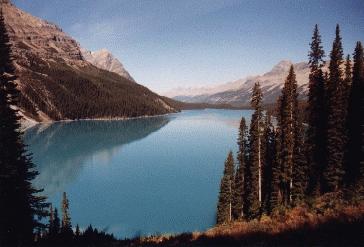
The Peyto Lake: The color is no fake
|
Nevertheless, the view of the lake is fantastic. Its turquoise color looks almost unreal, but there is
nothing fake. And now it is getting emptier, the coaches leave. Now we can enjoy the view and even shoot a few photos.
Yes, the guide books are right to call this view one of the highlights of the Icefields Parkway.
Just a pity that during the high season it probably looks like the whole day as during our arrival.
Now it is empty and we decide to go down to the south shore of the lake. The distance is 2.8 km, 275 m it goes down.
And that pretty steep. First, through dense forest. In two places you have a good view of the lake, the color
is always incredible. Then it gets light, and further views of the lake arise during the further descent in serpentines.
After 45 minutes we made it. Below a level of mud and sand, but frozen, you do not sink. In the lake,
the mountains are reflected, several streams flow into the lake. These probably come from the Peyto glacier,
just as probably this glacier is also responsible for the design of this plain. But now it is probably in retreat,
from here you can not see it at all.
The ascent takes an hour, during the whole trip we encounter no human soul. Because of the even more
photogenic views of the lake, we don't regret this trip.
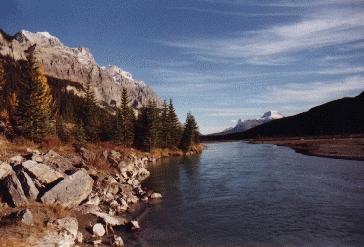
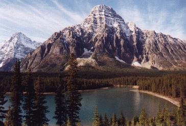
Typical landscape at the Icefields Parkway
| | |
In the parking lot we make a small picnic. One of these cheeky crows hops around on our hood
and can not be impressed by the horn. Then it goes on, again a few photo stops with great panoramas
of lakes and mountains, and around 4 pm we are in Lake Louise.
The Pearl of the Rockies is supposed to be that, but at first we do not see any place as we expected it to.
Actually again a large parking lot with a few shops around it, that's it. And a monstrous visitor center.
We ask for a cheap accommodation and are almost laughed at. So we only have the youth hostel. A double room
is unfortunately not available anymore. So we have to spend the night in the quad room at just under 20 euros per nose.
So we pay almost as much at the hostel as we did the last night at the motel, that's Lake Louise. After all,
the house is newly renovated, the decor new. Nevertheless, we want to limit our stay here to one night.
Since we have some plans for Lake Louise, we have to get started right away. At first to the lake,
which gave the place its name and therefore is also called Lake Louise. There is a huge parking lot near the lake,
and here is the Chateau Lake Louise.
The word "Chateau" is known as "castle", but the building on the lakeshore is actually a big box, which may not fit
in the landscape. Of course, as far as you stay in a room overlooking the lake, you have a great view from the balcony,
and the interior probably lives up to its name. At prices of 700 euros for a normal room per night
we see the whole better from the outside.
|
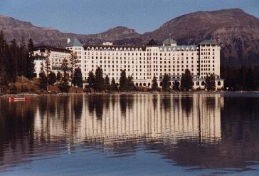
Chateau Lake Louise: After all, this look is free
|
From here, the "Plain of the Six Glaciers Trail" will take us on a distance of 5.5 km at 340 meters altitude
in a high alpine landscape, surrounded by six glaciers. At 5 pm we start hiking. First it goes on asphalt
along with many others along the shore of the lake. For them, maybe it's the evening walk before the lavish meal
in the chateau, which now reflects beautifully in the lake.
Is that really the "Pearl of the Rockies"? Yes, the lake is beautiful, but not necessarily prominent
among the others we've seen. So maybe that's more of a marketing slogan that is supposed to lure people
and justify the salted overnight prices.
After 2 km along the lake, it goes into the forest and uphill. Soon, however, the tree line is reached,
our starting point was already at 1700 m, now we are in a scree landscape. In the past, this was probably a single ice field,
now the individual glaciers have retreated into the side valleys, some no longer exist.
We meet a single hiker, who does not really know if he is still on the right path. Otherwise it is deserted.
Then a few hairpin bends, and we have reached the end of the official path. Time until here was 1.40h.
There are explanatory boards that tell us everything about the glaciers and mountains.
And there is the "Plain of the Six Glaciers Tea House", where you can drink tea or coke during the day.
You could go further to the Abbot Pass, from there you might see more glaciers.
But it is now too late, it is already dawning. We need 1:10h to walk back to the parking lot where we arrive at 8pm.
Definitely a recommended hike, which should probably be started at an earlier time.
In the hostel's kitchen, we cook up for dinner quickly, which is an advantage,
as youth hostels and backpacker accommodations usually have extensive kitchen equipment,
the use of which is included in the price.
Day 3: Fairview Mountain, Moraine Lake, Banff
The night in the quad room is a bit restless. At 6.30 clock an alarm rings, but it is not ours. We get up at 8 o'clock.
Breakfast in the kitchen. Check out, we drive back to the parking lot at the Chateau.
This time we have planned a more exhausting tour. We want to go to Fairview Mountain, this tour is 1000 meters
in altitude. At 10.20 am we start. A sign with bear warning, dense forest. An uneasy feeling comes over us, but we go on.
We talk aloud, which is always recommended as a good way to warn the bears from approaching people.
They then disappear by themselves, one hopes. Again and again we stop and listen, if there are noises, a rustle
in the undergrowth or something similar. Nothing.
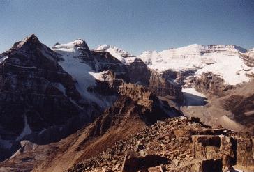
The view from the top of Fairview Mountain is fantastic
| | |
Behind us we hear another hiker. He claps his hands at regular intervals. Also a way to warn nearby bears.
We wait for him and join together in a trio. His name is David, he is a local and works in the sports business
in Lake Louise. But he was not on Fairview Mountain yet.
From the very rare attacks of bears on humans were almost always affected individual wanderers, almost never
were there groups of two or more people. In that sense, we already have a certain security.
The forest becomes lighter, the path is steep. In between, a look at the chateau and the place.
The weather could not be better. We are really lucky these days in the Rocky Mountains.
After about an hour we have reached the saddleback. This is the pass height that leads to Paradise Valley.
This is now completely blocked because a grizzly was seen there. It should be said that this is less for the protection
of humans than for the protection of animals. They should not get used to humans. "Keep animals wild" is the motto.
Failure to do so will result in a penalty of 1500 Euros.
But we do not want to go down to Paradise Valley anyway. No, rather, here begins the final climb to Fairview Mountain.
400 meters of altitude over a scree slope are to be completed. A tedious way, especially since we only wear normal sport shoes.
Walking boots with a higher shaft would be appropriate in view of the scree. In addition, everywhere are patches
of snow in the shadow of the stones, where you can easily slip and wants a better profile.
However, the views of the neighboring mountains make up for the effort. Above all, Mount Victoria at the end
of the Plain of the Six Glaciers Valley. At 12.15, that is after about 2 hours, we are on the summit, 2745 m high.
The highest point in the area, which can be reached on easy trails.
An overwhelming 360-degree panorama, good visibility to all sides. Very good you can also see the trail
of yesterday, the Plain of the Six Glaciers Trail. It looks like a gentle walk from up here, but there were also
a few meters to overcome. Lake Louise can only partially be seen from the summit, it has the same unreal color
from above as Peyto Lake. Everything, then, a matter of opinion.
|
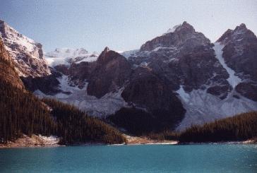
A great panorama also at Moraine Lake
|
At 12.45 we begin the descent. Down the scree slope is easier than expected. The further way is now partly muddy,
on the way up these places were frozen. Now a few other hikers come to meet us. At 1.45pm we are back at the parking lot.
We continue by car straight away. The destination is Moraine Lake, another mountain lake with a great panorama.
It is only a few kilometers away. After 15 minutes drive on a slightly worse road we are there.
The hype is fortunately not that big here. We only do the hike along the shore, 1.2 km on a level track.
There are beautiful views across the lake and the opposite glaciers. The famous postcard view, which can also be found
in almost every travel guide, can be enjoyed from a scree at the northern end of the lake. This scree has probably
originated at some point by a scree avalanche. Now bushes and trees are growing and banks have been set up.
The best time for this view would be in the early morning. Now the sun is exactly in the opposite direction,
dazzles and makes photographing impossible. You can not have everything. Well worth the detour here anyway.
And again at the Icefields Parkway
| | |
A short picnic in the car, refueling in Lake Louise, around 4pm we leave the place and drive
over Highway 1 to Banff, where we arrive at 5pm. Here we will spend a few days.
Remains to mention that there are also attractions and hiking on the route from Lake Louise to Banff.
These are best accessed from Highway 1A. This road, also called "Bow Valley Parkway", is the old road
connecting the two places and runs essentially parallel to the new one. For today there is not enough time.
So we pick this up for the way back (unaware that the main attraction, the Johnston Canyon, would now be closed in the postseason).