Picturesque Tofino - Walks in the Pacific Rim National Park -
Even more forests and more waterfalls - Walks in Strathcona Provincial Park -
Goldgrass Village Gold River - Port Hardy, ferry port towards Alaska
Travel data
| Date of the journey | September 2001 |
| Duration | 6 days |
| Report online since | 25.11.2019 |
| Updated | 25.11.2019 |
Day 4: Pacific Rim National Park, Elk Falls Provincial Park
Get up at 7.30, it rains. Breakfast with coffee and tea, we fill our thermos. Then visit the place Tofino.
Meanwhile, it has stopped raining. Picturesque the harbor and the bay. Seaplanes are available for a scenic flight,
boats for whale watching. A nice little place.
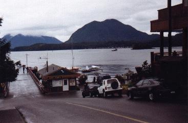
Tofino: Picturesque and tourist attraction number 1 in the Pacific Rim National Park
| | |
Then back to the national park. The first point is Radar Hill, which can be reached by car. A hill
that was partially cleared for radar installations during World War II and now offers a nice view.
The emphasis is on "should" because the view is almost zero. Only fog, too bad!
Next, we complete the Schooner Beach Trail. A mainly boardwalk path through dense rainforest. Huge cedars,
mossy, give the typical picture. Often it goes up and down stairs. After about 1 km we arrive at the northern end of Long Beach.
It just seems to be low tide, you can walk to a small island, you can look for shells. It goes back the same way.
The next hike is the Spruce Fringe Trail. 1.5 km long, the special are the Sitka trees,
which are among the tallest trees in the world. Parts of the way were from 20,000 years ago glacier,
100 years ago beach and now forest. Somewhere among us is supposed to be the huge skeleton of a whale.
Other parts are like the previous way real jungle. Dark, with many fallen trees on which new trees are growing,
moss, marsh. The bridges are often slippery.
|
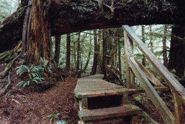
Typical boardwalk in Pacific Rim National Park
|
Our last route is the Rainforest Trail, which consists of two loops of 1 km in length. We decide on loop B,
where explanatory panels also deal with animal life. Otherwise also a lot of jungle.
It's 4pm as we say goodbye to the Pacific Rim National Park. A long distance is ahead of us, as we want to visit
the Strathcona Park tomorrow. First, we have to go back to the track from yesterday, there is no other way. Shortly before Parksville
then on the highway-like Highway 19 north.
From now on we make much better progress, the road is almost empty. Also the weather gets better,
the longer we are on the way. No wonder, the rainy west coast we have left behind us, we now drive
on the east side of the island.
Exit Campbell River, a few miles further is Elk Falls Provincial Park, here we want to stay overnight.
It's already past 7pm when we arrive. High time to set up the tent. The overnight fee is 9 euros, this time the money
is collected by park employees. A very popular campsite is that, it is quite crowded. Neither we get a place
right on the river, and the way to the toilet this time is a bit longer.
The ground is not as hard as last time, which makes pitching easier. Only the fire making does not work
this time, the wood is just too wet. This includes brushwood and pine cones. So the kitchen stays cold this time.
At 9.30 pm we go to bed, again at the sound of the river.
Day 5: Strathcona Provincial Park
At 6.30 am we get up. A black rabbit does not bother looking for food, and criss-crosses our place for fifteen minutes.
Dismantling, packing up, short breakfast in the car. Then to the parking lot at the Elk Falls. Finally, we want to visit
the waterfalls, which gives the park its name.
We are there before 9 o'clock. A ranger is sitting in his car, ensuring safety. He tells us that we are the first today.
He probably does this every morning. Then to the waterfall. Surely the most powerful on our recent trip on Vancouver Iceland.
Huge volumes of water whizzle down there and have drilled a large basin in which the water can now collect.
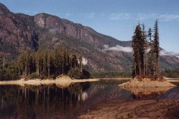
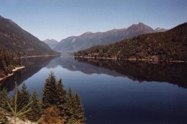
View over the Buttle Lake.
| | |
Continue towards Strathcona Provincial Park. It is very foggy, but it does not rain. Soon we reach the entrance
to the park. The place is beautifully located on the lake, just open the clouds, wonderful pictures.
The day promises to be beautiful. We decide to complete some of the trails in the area of Buttle Lake.
As we drive south to the east of the lake, the west side is wonderfully illuminated by the sun. Important for the photos!
A first photo stop at the lake, then the Lupine Falls Trail, 600 m long, 40 meters in altitude. There are
extremely many mushrooms here. Indicates the high humidity of the area, but today it is beautiful.
Next, the Auger Point Trail, 400 m long, 20 meters in altitude. Also leads through forest,
but is apparently not used so often, namely is rather overgrown.
Interesting is the Karst Creek Trail, 1.3 km long, 80 meters in altitude. The special is the karst
underground, which contains many underground cavities. The Disappearing Creek is a creek that suddenly
disappears from the ground and continues to flow in one of these cavities. There is also a waterfall that disappears in the ground.
|
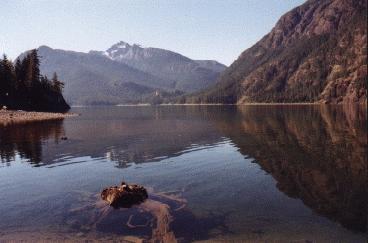
View over the Buttle Lake
|
Not so recommendable is the area southwest of the lake. There is a quarry and a huge area where ores or minerals
or whatever are mined and processed. The boundaries of the park have been set so that this area is just outside the park.
But also three longer trails are currently closed. Not very nice, what they are doing here.
So we visit the Lower Myra Falls. 1 km out, 1 km back, 80 meters in altitude. There are a striking number
of toadstools and two viewpoints on the waterfall. The promising Flower Ridge Trail turns out to be a one-day hike
with 1300 vertical meters, but we don't have enough time for that. So we settle for two shorter hikes,
the Shepherd Creek Trail (1.8 km, 80 meters in altitude) and the Wild Ginger Trail (800 m, 40 meters in altitude).
In total, we have now completed 7.9 km at 370 vertical meters.
We want to stay overnight at the campsite at the northern end of the lake.
It's not as busy as it was last time, it costs about 11 euros, and this time it works quite well with the fire.
At 9 pm we go to bed.
Day 6: Gold River, Port Hardy
At 7 o'clock we get up, at 9 o'clock we start. The last paths in Strathcona Park are on the program.
The Lady Falls are described on the explanation board as "beautiful". However, this does not do justice to the reality,
they are far too big for that, and you are guaranteed to get wet on the observation platform.
Next stop at the Elk River Observation Deck. Here the so-called "Roosevelt moose" live,
a very special species. Under a high-voltage power line, one can see a swath on the other side of the river,
where the moose meet in the fall and winter in the morning. Ideal time, but unfortunately there are no moose there.
Well, with animal observations, it is not so easy.
View over Buttle Lake
| | |
And so we leave Strathcona Park, which seems to be a kind of insider tip. It offers
a lot of possibilities and untouched nature, but not many people come here. Maybe it's different in the summer.
At 11.30 am we are in Gold River. A place founded by prospectors. There is not much going on here today
and there are hardly any tourists coming here. Only attractions are a few caves in the area.
This is for cave enthusiasts! That would be interesting for us as well, but it would take more time.
So it remains the Peppercorn Park Trail, which leads along the river. It is 1.5 km long,
and it is constantly going up and down. Easy to underestimate, it takes an hour to get there and back.
A small purchase in the local supermarket, many shops do not exist.
And then we start in the direction of Port Hardy. The first 63 km on a gravel road, this is the real adventure.
Start at 1.30pm, maximum speed 40 km per hour, average 30 km per hour. We constantly have to work around the many potholes
in the slalom, but it is hard to avoid driving into the middle of the potholes regularly.
Huge trucks loaded with wood are coming towards us, driving much faster than we do. Of course they have
the better tires and the better shock absorbers. From behind approaching pickups we let overtake.
But then there is hardly anything going on, we drive through a rather deserted area. But a bear does
not want to meet us. Whole slopes are cut down here, a sacrilege of nature. But Canada is the world's largest timber supplier,
and that's where it has to come from.
At the end of this route still a lack of clarity with the sparse signage. But finally, after two hours,
we reach Highway 19 and finally have asphalt again under the tires. Now, of course, it is much faster,
top speed is 100 km per hour. There are no sights anymore, we race through Port Hardy and arrive at 5 pm.
Just in time to reserve a Bed & Breakfast accommodation. The next morning, the ferry
will take us on the so-called "Inside Passage" north to Prince Rupert. At 6.30 we have to be at the ferry terminal
the journey will take 15 hours. And so our stay on Vancouver Island ends.