Three of the largest natural bridges in the world at the Natural Bridges National Monument
- The Delicate Arch as the Landmark of the State of Utah
- Countless other arches and bizarre rock formations in the Arches National Park
- And the Hickmann Bridge in Capitol Reef National Park
Duration: 3 days
Day 1: Natural Bridges Monument
From Monument Valley in the south we drive towards National Bridges National Monument.
The distance is not too far, but the track is spectacular. Right at the beginning we are heading for a rock face,
and you do not see where it could go on for a long time.
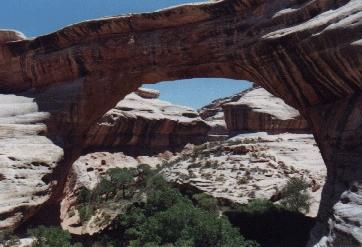
The highest in the park: The Sipapu Bridge
| | |
Then a road becomes visible, which winds up in serpentines. 3 miles gravel road, but it is not a problem.
But we soon have a fabulous view over the wide plain and many rock formations. In the distance the rock towers
of Monument Valley. Once at the top we are on a plateau and the road continues paved. The vegetation here
is much more abundant than below, everything looks very green.
At 11 am we arrive at the Natural Bridges National Monument, which contains three of Earth's largest natural bridges.
At the beginning the obligatory stop at the Visitor Center. Then we go on the 9 miles long circle road through the park.
Each of the three bridges can be "experienced" in two ways: There is a viewpoint from above, from which one can see them well.
And there is always a way down, so that you can sometimes get under the bridge. In addition,
a longer trail leads past all three bridges.
Natural bridges are washed out by rivers. Because the predominant sandstone here is particularly suitable,
they occur so concentrated. There is no river here, at least not right now. But very well a riverbed, which is certainly
filled at heavy rainfall. The river water, but also rain, wind and frost continue to work on the bridges until they collapse
in the near or distant future.
The first is the Sipapu Bridge. It is the highest and, at 81 m, also has the largest span of the three.
The way down is varied. It leads over rock, serve as a marker cairn. Once we have to climb down a ladder.
After walking for some time under an overhanging rock face, we get a much better view of the bridge than from the viewpoint
on the road. You should definitely go this far.
|
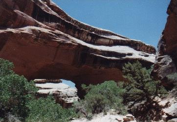
Kachina Bridge: Almost like a cave with two exits
|
A slightly steeper path and two more ladders finally bring us to the foot of the Sipapu Bridge.
It is very green here, there are a lot of trees that do not look dried out. A sign of abundant water.
And the bridge itself is really huge. A little bit of an uncomfortable feeling creeps up, if you stand directly below it.
But this bridge is probably to exist a few more millennia.
Number two is the Kachina Bridge. Both in terms of the order on our way and in terms of their data.
It is only a little lower than the Sipapu Bridge, but at 62 m has a much smaller span. Concerning such comparisons,
there are no internationally consistent methods for determining the dimensions of natural bridges. Therefore,
the classification into a worldwide "hit list" is very difficult.
It is clear, however, that the Kachina Bridge is the youngest of the three bridges in the park.
Because it is by far the widest and thickest. Clearly, river water and other weather conditions have worked at least.
At the vantage point from the road it is hard to tell if it is a natural bridge or a cave.
Therefore, we also want to go this trail. Again mainly over rock, the trail leads down this time in serpentines.
The last part runs on sandy ground in the riverbed. Again, a comparatively lush vegetation.
And you really feel below the bridge more like a cave with two exits. The acoustics does the rest.
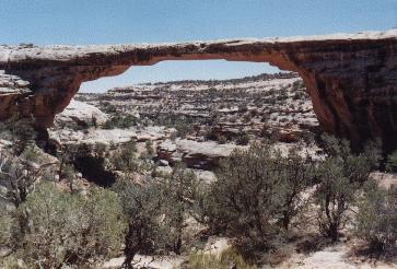
Delicate and fragile: The Owachomo Bridge.
| | |
It is already quite hot again. And so we are glad that the way to the last bridge is short.
It's the Owachomo Bridge, and it's by far the oldest bridge in the park. It looks very fragile,
is only 2.70 m thick at its thinnest point. Its days are already counted. Nevertheless,
the experts do not expect with a collapse immediately, because you can still walk around under it.
So maybe it still has 100 or 200 years to go.
Overall, the Natural Bridges National Monument is a nice little park, which is apparently rarely visited
and thus not as crowded as the well-known national parks. Nevertheless, it offers natural wonders
that are worth spending a half or full day here. We really can only recommend it.
Day 2: Arches National Park
A few days later we are on the 666 in the direction of Monticello. On the right, not far from the road,
we can see the Wilson Arch, one of the many natural rock arches in the area. It is already a foretaste
of what is is to come today.
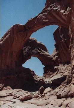
Twice comes the Double Arch
| | |
A few miles further, announced on giant billboards, the Hole'n the Rock. This rock hole is completely artificial.
Someone built an apartment in a rock and provided a lot of kitsch. Completely US-style, this has now been converted
into a tourist attraction, and you have to pay admission to view a part of it. We leave that alone for time reasons
and only use the toilets. They are alright.
At 9:15 am we are in Moab, the main tourist town in the area. Shortly afterwards we reach the Arches National Park.
In contrast to the Natural Bridges, where a river or stream is responsible for the formation,
here are other weather conditions such as rain, wind and frost. For this reason, there may also be rock arches
in places where no river has ever flowed, e.g. also on the top of a mountain.
A line of vehicles is parked in front of the entrance, the park is more sought after than expected.
At the entrance we can already reserve our pitch on the campsite, so it worked. We should go until around noon
and then choose the place, it will not be allocated. So that means a ride of 18 miles through the park.
It's like driving through a dreamland. Nature has created here rocks in the most adventurous forms.
It is by no means only the arches that gave the park its name. We pass by all the attractions that we will take a closer look at later.
Around 10 o'clock we have chosen our pitch. There is not much shade, but the campsite is picturesquely situated
at the foot of red sandstone cliffs in imaginative shapes, very nice. At 10.30 o'clock we have set up the tent
and go on our sightseeing tour.
Back to the "Balanced Rock", a massive boulder that lies on a rather thin "rock stand". Until 1975 there was a second one
right next to it, which then collapsed. A short path leads around the rock, but the most spectacular and well-known view
is from the parking lot.
|
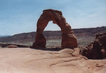
The Delicate Arch, a landmark of Utah
|
The Windows Section is reached by a side road. The North and South windows are two holes in the rock,
looking from far off as round windows, side by side. The neighboring Turret Arch derives
its name from the turret i.e. the small tower besides ist.
Not far away is the Double Arch, which consists of two consecutive arches.
The attraction of the next branch is the Delicate Arch. You can take a distant look at it from the viewpoint.
But that does not do justice to this arch. You have to see it up close! A total of 3 miles round trip is required.
At 160 meters altitude, oppressive heat and blazing sun a strenuous affair. Actually, the evening
would be more appropriate, but that would mean a renewed back and forth. So now!
The trail starts at the historic Wolfe Ranch. It is quite appealing, leads mostly over bare rock
and directly to the Delicate Arch. You can even stand under the arch, which is the landmark of the state of Utah.
This is really one of the highlights of this park as it stands in the landscape. One wonders how it could emerge.
You also have a nice view of the arch from another hole in the rock to which you have to climb about 5 m from the path.
This trail is highly recommended!
The Broken Arch does not look that broken
| | |
For half an hour we sit here in the shade and enjoy the view, then we go back. Shortly before reaching
the ranch a turnoff, which we have reserved for the way back. An Indian rock painting can be admired here.
It is the best preserved we have seen so far. Above all animals are shown. You can see goats, but also riders on their horses.
Easy to reach from the road is the Sand Dune Arch. An insider tip! The arch is not large, but the path leads to it
through a narrow gorge, the ground is completely covered with red sand. There is a lot of shade here,
which is good after a hot day. Few others seem to know this place. A family is having a picnic, the kids are romping
in the sand and on the rocks. Another family is completely asleep and enjoys the peace. More people are not there.
We also visit the Broken Arch. A path without shade leads from here across the plain to the opposite group of rocks.
This arch is already worth seeing, but there is also an approximately equal distance from the campsite here.
This is shady and is therefore recommended rather in the hot time of day.
We drive back to the campsite and have dinner first. The kitchen stays cold as fire is currently prohibited.
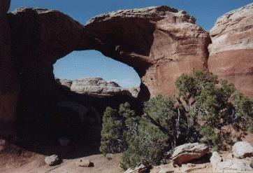
We stay here until about 7.30 pm, then we start our evening hike, in the nearby Devil's Garden.
As many as eight arches are listed on the map here, one must also have seen this.
|
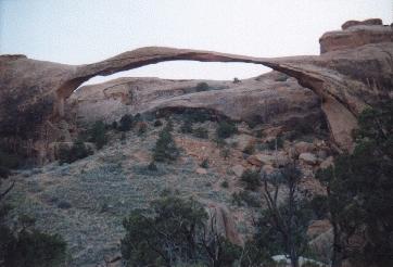
Landscape Arch: The longest arch in the world?
|
An easy path leads to the Landscape Arch. This one argues with the Kolob Arch in Zion National Park
for the predicate of the longest arch in the world. It looks very thin and fragile. Apparently, one expects
the early collapse of this natural monument, because the detour below the arch is now closed.
As unfortunate as that might be, that's the way things are going. The age of a rock arch is limited,
and at the latest Kolob Arch would have won the race.
From here, the trail becomes impassable and more exciting. It goes through a narrow gorge, steadily upwards.
The path runs partly over the bare rock. Right, right on the edge of the road, is parallel to the rock wall of the Wall Arch.
Whether it owes his name to this fact?
Then the end of the ascent is reached, a turnoff. 0.9 miles to Double O Arch, 0.3 miles to Partition Arch
and 0.2 miles to Navajo Arch.
We have to decide. It is getting dark, so we take the shortest option to Navajo Arch, hidden in a side canyon.
It is certainly not one of the most spectacular arches in the park, but it still has a much longer future than the Landscape Arch.
In the twilight we return and are back at the Trailhead at 9.30pm. We each eat a few peanut butter sandwiches
and are in bed around 11pm.
Day 3: Capitol Reef National Park
We get up at 6.30 am because we want to do something in the Arches National Park. Tent down, short breakfast,
there is cereal. At 7:45 am we're back at the Trailhead Devil's Garden. We still want to look at two arches
that are not far from here. Pine Tree Arch is quite a large arch, through which you can also go through,
but not should. Tunnel Arch is located high in a rock face and could at best be reached by a difficult climbing.
Back on the road, the Skyline Arch is just a short detour, this arch could also be reached from the campsite.
This is already the thirteenth arch we see in this park, but also the last one. We drive towards the exit.
The section called "Courthouse Towers" does not have arches, but some interesting rock formations.
The "Tower of Babel" is a massive, towering boulder, while "The Organ" comes with its side-by-side organ pipes.
Almost filigree are the "Three Gossips", which could well pass through as a modern sculpture. From La Sal Mountains Viewpoint
you can gaze across this and beyond to Balanced Rock and Windows Section. A nice place.

The so called windows really look like windows
| | |
Around 10 o'clock we leave the park, for us one of the big highlights of this area. We drive to Moab,
where we got through yesterday. A nice little place, there are shops, cafes and restaurants. For mountain bikers,
it is the Eldorado. There are numerous routes in the area, and here you can book everything, of course, borrow the equipment.
We do not do that, but we still stay in the city for a while. In the early afternoon we continue north.
In Green River, we stock up on our food supplies, and then we go on the 24 towards Capitol Reef.
The route is quite interesting. Although not much is growing again,
there are many rock formations to marvel at. We have already 3pm, for a long time we want to take
a little break and eat something. But we do not find a suitable place. Then we come to Hanksville
at the junction for 95. Next to Johnson's Gas & Supermarket there is a picnic table in the shade, finally!
First we have a picknick.
Soon after that we arrive at Capitol Reef National Park, which provides us with great mountain panoramas.
The park has an unusual shape, perhaps 70 miles north-south, but sometimes only 5 miles east-west.
The thoroughfare is marked by early activities of the Mormon immigrants, especially the Fruita Historic District.
After two photo stops at the Behunin Cabin and the view to the Capitol Dome we drive first to the campsite and reserve a place.
|
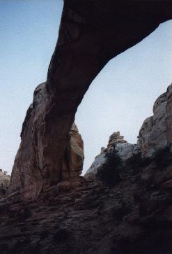
Hickman Bridge: Capitol Reef also has its bridge
|
The campsite is nicely located between fruit trees, finally we are not allowed to pitch our tent on dust,
sand or gravel, but there is grass here. You may eat ripe fruit here for free; only what you take with you
costs something. Unfortunately, nothing is currently ripe. Deer roam freely in the terrain and are quite trusting. A nice area.
We drive now to some points, which we just passed. The old Mormon schoolhouse, a tiny building.
Through the window you can see the entire facility. Then there are a lot of Native American petroglyphs.
Partly one thinks to see extraterrestrials. To protect the drawings you are not allowed to get close,
but at the observation point there are telescopes installed.
At 7 pm we start our evening hike. The goal is another natural bridge, the Hickman Bridge.
A beautiful hike through gorges is that, not too difficult with a length of 1 mile and a difference
in altitude of 100 m. The low sun now paints the rocks in orange, a nice mood. After half an hour we arrive
at the Hickman Bridge. The size makes it easy to keep up with most of the arches in Arches National Park,
but you will find much fewer people here.
When we get back to the campsite, it's almost dark. Only now do we set up the tent, we make a fire
and cook soup again in the can. There is tomato and forest mushroom soup, around midnight we are in bed.
Remarks
In southern Utah, the natural bridges and arches are piling up like nowhere else in the world.
This area is therefore also the first choice if you want to see these types of natural phenomena.
In addition to the parks mentioned in this report, there are many more arches and natural bridges
in the Canyonlands National Park, for which time was unfortunately not enough. The Kolob Arch
mentioned in the text is located in the remote Kolob Canyon of Zion National Park.
Finally, the mighty Rainbow Bridge has to be mentioned, which can only be reasonably reached by a day trip
by boat over Lake Powell. Completely impossible is to enumerate all other interesting arches and bridges
that are also outside the national parks.
The cataloging of arches and natural bridges has been undertaken by the Natural Arch and Bridge Society (NABS).
It runs an internet site at www.naturalarches.org
The area is sparsely populated. There are few places and few accommodations. After all, Moab is such a place,
which is also well suited as a starting point for activities and sightseeing. Otherwise, the campsite is recommended,
as there are many possibilities. Most of the places in the parks are rather Spartan, but you're right in the middle of it all.
They are a little more luxurious outside, but you always have to take a ride in and out.
Of course, public transport is scarce due to the mentioned sparse population. A rental car is actually a must.
It is particularly convenient to reserve this online in advance of the trip. Under the keyword rental car United States
are numerous providers. The rental car can then be picked up at the destination airport. So you never have to wait for the bus,
and it always gives you the flexibility to make spontaneous detours from the planned main route.
Because often you get the best tips from other travelers that you meet in the area.
The combination of rental car and tent proved to be ideal. Then you can stay almost directly
at the nature attractions and experience the national parks much more intense. Alternative to this would be the camper.
But beware: In the summer, on weekends and public holidays you should either arrive early at the campsite
or make a reservation in advance, otherwise it could be scarce.